


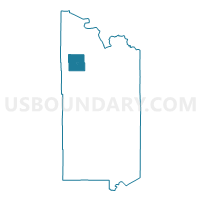
Leiding Twp. Voting District, St. Louis County, Minnesota
About
Outline

Summary
| Unique Area Identifier | 604268 |
| Name | Leiding Twp. Voting District |
| County | St. Louis County |
| State | Minnesota |
| Area (square miles) | 140.93 |
| Land Area (square miles) | 122.54 |
| Water Area (square miles) | 18.38 |
| % of Land Area | 86.96 |
| % of Water Area | 13.04 |
| Latitude of the Internal Point | 48.06500120 |
| Longtitude of the Internal Point | -92.84287350 |
Maps


Graphs
Select a template below for downloading or customizing gragh for Leiding Twp. Voting District, St. Louis County, Minnesota


Neighbors
Neighoring Voting District (by Name) Neighboring Voting District on the Map
- Beatty Twp. Voting District, St. Louis County, MN
- Camp 5 Twp. Voting District, St. Louis County, MN
- Orr Voting District, St. Louis County, MN
- Portage Twp. Voting District, St. Louis County, MN
- Unorg. Prct. 12, St. Louis County, MN
- Unorg. Prct. 21, St. Louis County, MN
- Willow Valley Twp. Voting District, St. Louis County, MN
Top 10 Neighboring County Subdivision (by Population) Neighboring County Subdivision on the Map
- Leiding township, St. Louis County, MN (400)
- Beatty township, St. Louis County, MN (372)
- Northwest St. Louis UT, St. Louis County, MN (301)
- Orr city, St. Louis County, MN (267)
- Portage township, St. Louis County, MN (170)
- Willow Valley township, St. Louis County, MN (126)
- Camp 5 township, St. Louis County, MN (35)
- Gheen UT, St. Louis County, MN (18)